Exploring North East, MD by Sea and by Land
North East is a quaint town at the head of the Chesapeake Bay in Cecil County, MD, only about 50 miles from Baltimore and Philadelphia and a quick 20 minute drive from the towns of Havre de Grace and Chesapeake City.

Throughout North East’s early history, the North East River played a crucial role. Prior to the arrival of Europeans, the area provided abundant hunting and fishing grounds for early Native Americans. Captain John Smith’s expedition reached North East in 1608 while mapping the Chesapeake Bay. Soon after, European settlers from Delaware and Pennsylvania began moving south into the area while settlers from Virginia and other parts of Maryland began arriving by water. The North East River was at the center of the town’s early prosperity; numerous mills were built along its shores, fish were caught in abundance, and farms flourished. By 1850, the town was fully incorporated.
Today, North East is a popular destination for boaters and non-boaters alike. For more information on the town and Cecil County, click to northeastmd.org and ccgov.org.
Main Street
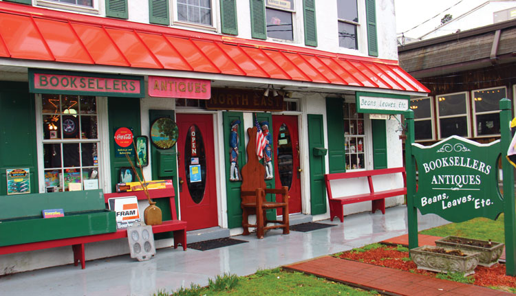
The town’s quaint Main Street is lined with various eateries, boutique shops, and antique stores. At Beans, Leaves, Etc. you can grab a latte or bag your own specialty tea. Attached is Bookseller’s Antiques which has everything from antique bikes to, you guessed it, books. You can find homemade fudge at North East Chocolate & Gifts and unique, fun jewelry at The Silver Buckle. The Cat’s Pajamas features eclectic pieces from local artists, including paintings, photography, and even terrariums. Main Street even boats a tackle shop and a tasting room for the Turkey Point Vineyard.
Elk Neck State Park
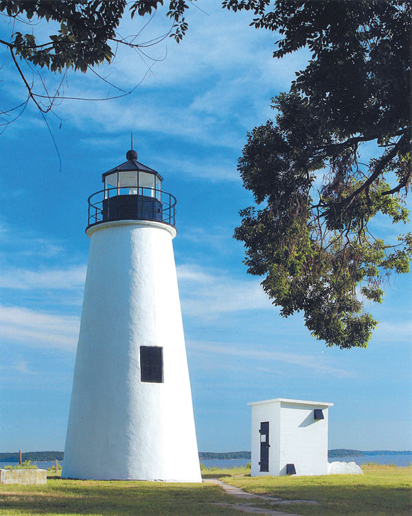
If visiting Cecil County for the first time (or even tenth) a visit to Elk Neck State Park and the Turkey Point Lighthouse is a must. The lighthouse was built in 1833 and sits on a 100-foot bluff at the confluence of the Chesapeake Bay and the Elk River. On a clear day, the views from the cliffs are spectacular. The park is about a 15 minute drive from the center of town and the hike to the lighthouse is about a mile-and-a-half roundtrip on a fairly flat path through the woods. If planning to visit on a weekend, be warned that the small parking lot often fills to capacity – plan to hike early in the morning or after 6 p.m.

North East Community Park
Just past the Nauti-Goose Restaurant you’ll find the North East Community Park. The 13-acre waterfront park features walking paths, a playground, picnic tables, and even offers license-free fishing from the shore. Next to the Park is the Upper Bay Museum, open Memorial Day through Labor Day, Saturdays and Sundays. The museum is free to enter and houses a large collection of hunting, boating, and fishing artifacts native to the Chesapeake Bay, along with one of the country’s best collections of marine engines.
Upper Bay Sailing Scene
Hances Point Yacht Club: Located on the Eastern Shore of the Northeast River, HPYC is a true ‘do it yourselfer’ yacht club. Members maintain the facilities and equipment and are regularly involved in the restoration of ‘Good ole Boat’ sailboats on the grounds.
North East River Yacht Club: The northernmost yacht club on the Bay! Featuring an on-site restaurant and bar, floating piers, deep-water slips and moorings, as well as junior sailing, racing, group kayaking, paddleboarding, and summer sailing camps for kids.
Northern Star Hunter Sailing Association: One of two Hunter Sailing Associations on the Chesapeake, NSHSA is made up of about 60 families (boats) who sail primarily on the upper Bay.
Local Tips for Arriving by Sailboat
“If you come to the river in a deeper draft sailboat, say above five-foot draft, you need to heed the channel which runs along the eastern side, along the points from south to north, Turkey Point, Rocky Point, Elk Neck State Beach, Red Point, and Hances Point. In the upper reaches, the day markers mark the mid-point of the channel; when you get up river, follow the charts. There is a sandbar marked by a red nun just across from Mcdaniel. If you stay to the east side, you can run the river all the way to North East Community Park.
“If you are careful of depth, you can anchor in Cara Cove just above red point. It has some protection from south winds and directly across the river from there is what we call Hollywood Beach, a sandy bottom area which is away from the channel where you can anchor and swim in three to six feet of water. Beaches do run along the points on the east side and you can anchor close in, however you are close to the channel and wakes and the bottom is somewhat muddy. Deeper water close to shore between Rocky Point and Turkey Point underneath the cliffs is a popular spot we call Gellers Hole. For the more adventurous shallow draft boats there is the Susquehanna Flats and Sand Island between the North East River and the Susquehanna River, and the channel from Spesutie Island to Havre de Grace.” ~ Jeffrey Wettig
Check out Jeffrey’s podcast “Shooting the Breeze Sailing” at theescapepods.com.
For more articles about Chesapeake Bay destinations, click here!


