Sailing the shallow Bay
Ah, sailing the shallow Chesapeake Bay! Regional cruising sailors know all about shallow-draft boats, shoals, silted-in channels, and the embarrassment of running aground. It's something most destination articles skirt around or skim over (pun intended). Longtime Rock Hall, MD, sailor Captain Joe Musike of Experience Sail gives us this cheeky take on his neighborhood "bar."

The Bar
The Bar: she’s a mythical beast that lurks just below the surface west of Rock Hall, MD. If you don’t respect her, she will leave you high and dry, wishing you headed straight to G1. Or, maybe she grew old years ago and left for Florida not announcing her departure. Those “threes” and “fours” on the chart are unsettling to say the least… when were those depths measured anyway? Who knows? I wouldn’t be surprised if it was a guy with an actual lead line. This summer we’ve all seen the dredges north of the Bay Bridge, maintaining the channels into Baltimore and points north, the Army Corps of Engineers zigzagging their way up and down the shipping lanes taking soundings. No commercial need to survey the Bar.
Sailing out of Osprey Point Marina, I can personally attest to the varying opinions on the Bar. Some don’t go near it, no way. Others all have their own track they swear by. Follow the Brewerton Channel [Eastern Extension] range all the way in. Head due west after passing south of G5 or parallel the range to the Bay Bridge on the southeast side. Line up this shack with that tree… I’ve heard them all. I have seen mid-sized powerboats go all the way to G1 and large sailboats seemly cross anywhere. Most will honor G3. All honor G5. Is it worth it? I don’t know anyone that selects the longer route option on the road, but then again, the car usually doesn’t go aground.
That's "technical speak"
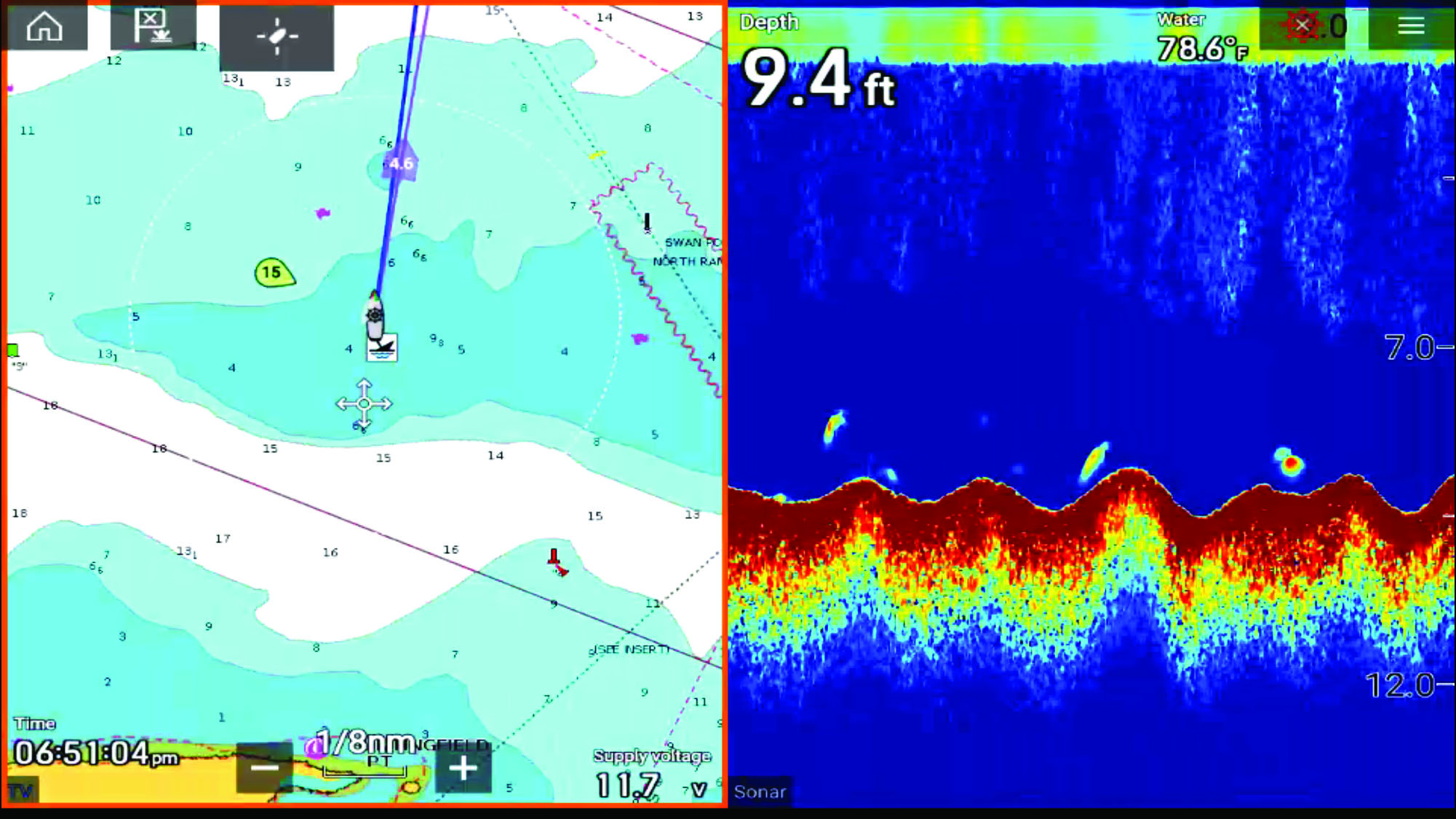
Yeah, the charts are not really that accurate. Sure, the depth soundings are mean lower low water (MLLW), but I have found them to be off by as much as a lot. That’s technical speak for “Don’t rely on me.” Tides in Swan Creek measure typically two feet or less. You can see from the screenshot that I was showing double the charted depth at plus 0.6-foot tide. And yes, the offset for my depth transducer is correct. The survey vessel in this case is a Beneteau 50 drawing five feet, nine inches.

I covered the entire Bar from an east to west line 200 yards north of the Swan Point Channel North Range Light [south] to G3 and did not touch bottom, wasn’t even scared. I started with a rising tide, calm weather, and a relatively slow speed anticipating something. After a couple of hours, I had a new chart of the Bar thanks to Sonar Chart Live.
Test the waters yourself
What do I do now? I always honor G5 and don’t worry too much, but I still have my favorite tracks. It certainly is nice to set the sails after passing Gratitude and head directly for the Magothy River or Bodkin Creek. When we have strong north winds and blowout tides, I honor G3. Although if it gets that low, I probably can’t get out of Swan Creek anyway. Local knowledge can save you some time, even get you into places that appear inaccessible. Marina personnel, towboat operators, salty curmudgeons may have the most up-to-date local knowledge. Navionics has a layer call “SonarChart,” and the Army Corps of Engineers publishes all of their dredge surveys, all useful information, but the captain still needs to make the call. Sometimes you just have to test the waters yourself. See you on the Bar.
by Capt. Joe, who can be found here.


